21 Danish Crop-Circles from 1994-1999:
field-reports, aerial photos, and diagrams
This information is summarized, translated, and compiled in Feb., 2001, by Jonah Ohayv, from archive material collected by the Dansk Korn-Cirkel Gruppe. Illustrations scanned by Jonah and Bjřrn Boman.
In all, 39 Danish crop-circles have been reported since 1994, some of which bear the signs of man-made creation. The qualities have been improving, and it would seem that certainly year 2000 brought classical "genuine" circles, also compared to British prototypes. See the 7 accounts from that summer's formations here.
Through earlier years, several formations have been close replicas of each other's basic form (simple circles, 2 concentric circles divided into 8 arcs, and a spiral). Also several simple formations appeared in one area, the small island Lolland.
Here are 21 summaries of these reports.
1999
1. Date created: July 29, 1999
Date measured: July 31
County: Sjćlland
Location: Vig, near Nykřbing Sj.
Crop: wheat
 click here
photo by Sřren Holmberg
click here
photo by Sřren Holmberg
Description: A 41-meter formation, easily viewable from the road. The "circles" and ring were more square in places and nicely made, excepting the ends of the arc, which were very messy. The axis through the circles (drawn onto this photo) pointed precisely to the middle of 3 flagpoles on the other side of the road, which were conceivably used as a marker under construction. For measurements, enlarge the diagram.
 click here
Adapted from Karlotto Ernst Lundholm's field-report.
2. Date created: July 19, 1999
Date found: July 19
County: Jylland
Location: Skibby, 4 km. from Ĺrhus
Description: A 16-meter circle surrounded by a broad ring at 32-meters diameter. A thin path, 8 meters long, connected the ring with another 4-meter circle.
Measurements by Vibeke Tranberg.
1998
1. Date created: ?
Date measured: late August, 1998
County: Fyn
Location: Břsřre, near Storebćlt
Description: The formation was quite old when it was measured. A complex form with regular dimensions: A kind of "vescica pisces" with a dolphin of standing crop within the circles' instersection, with a tiny circle in its center. Paths of .3 meters ajoin the largest circle with two further, smaller circles and connect them too. A fine form reliably measured, but with no air photos.
For Esben's diagram, click here.
Measurements by Esben Pedersen and Villy Allesř Rasmussen.
2. Date created: ca. July 15, 1998
Date found: ca. August 15
County: Jylland
Location: Rćrup, Vendsyssel
Crop: immature
 click here
 click here
photos by Jens Morten
click here
photos by Jens Morten
The formation was 59.3 meters long, and aligned almost precisely West-East. A 19-meters large and 1.25 meters broad ring. A 2.2 meters broad path, with a 3.3 meters circle halfway down it, connected the large ring to another ring, 13.2 meters large and 1.15 meters broad. The large ring was broken by a disconnected "key" or "hammer" with unclear contours, 16.7 meters long. A grapeshot circle was further off in the field. Geometrical irregularities several places, plus pole-holes in the centers of the two largest circles.
 click here
Measurements by Torben Birkeholm and Casper Christensen.
3. Date created: July 31, 1998
Date measured: August 4
County: Jylland
Location: Grřnbćk, 10 km. south of Ĺrhus
 click here
photo copyright Midt-Jyllands Avis
click here
photo copyright Midt-Jyllands Avis
Description: All straws were broken near the ground. The ends of the half-moons were messy. Inexact geometrical execution of several types. No magnetic anomaly. The farmer found footprints from rubber-boots in and near the formation that morning.
For the formation's diagram and measurements, click here.
Adapted from Jřrgen Larsen's and Albert & Albert Hauser's field-report and diagram.
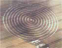
4. Date created: July 27, 1998
Date measured: July 31
County: Jylland
Location: Egemark Gods, Odsherred, Fĺrevejle
Crop: wheat
 click here
photo by Sřren Holmberg
click here
photo by Sřren Holmberg
Description: A clockwise spiral of 10 revolutions, 84 meters broad, in a green wheat-field. Most corn-straws lay flat down, but at the tractor-lines, they were broken at 10-15 cm. above the ground. A bird-nest containing unbroken eggs was found in the spiral's path. The path's breadth was 1 meter, so theoretically, it could have been made by a garden-roller 70 cm. in radius, unwound on a rope 42 meters long, and then finished with a 1-meter stomping-board. There were no magnetic or electrical anomalies.
Adapted from Ove Larsen's and Karlotto Ernst Lundholm's field-report.
5. Date created: July 1, 1998
Date measured: July 5
County: Jylland
Location: Odsherred, Vejrhřj, near Vindekilde
Crop: wheat
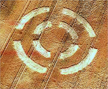 photo by Sřren Holmberg
Description: This formation copies the same symbol found closeby in 1995. This new 8-arced agriglyph in green wheat was 40.3 meters broad, and the breadth of the arcs was approximately 3.3 meters. The straws were almost all broken at a height of either 3 cm.s or 15-20 cm.s, but in some places they were flattened at the earth-level. The crop-lay at the arc-ends was turned around as if made by a board. No dowsing or compass-anomalies.
Adapted from Gunner Frederiksen's and Karlotto Ernst Lundholm's field-report.
1997
1. Date created: August 4, 1997
Date measured: August 9
County: Jylland
Location: Ĺlum, 14 west of Randers
Crop: rye
 click here
 click here
photos by Erik W. Olsson
click here
photos by Erik W. Olsson
Description: There were sharp boundaries between standing and lying rye. The circle was divided into 17 rows, each 50-cm. broad. All stalks were bent near the ground but not damaged, with intact root-connections. The seeds in the layed ripe crop were still on their stalks.
There were no signs of downed rye between the long corridor and the little rectangle four meters from it, and no access between them from tractor-paths.
Around 11 P.M. that night, a woman saw two large and 3 small sharp lights nearby, all in all about the size of the moon, which moved together across the sky for about 6-9 seconds, and then disappeared. About 3 weeks earlier, a fisherman had observed very strong lights in a nearby woods, which came and went several quick times in succession.
Jens Glaving tried growing seeds from the formation's center and from far away in the same field. The circle's seeds took longer to sink in water, grew much earlier than the field's control seeds, and developed much more than the controls, which in turn developed normally.
 For the detailed diagram, click here.
Adapted from Jřrgen Larsen's and Albert Hauser's, and Kristian Elmquist's field-reports. Silhouette from the JL and AH report. Diagram made by Lars Tofte Stampe.
2. Date created: July 23, 1997
Date measured: August 9
County: Lolland
Location: near Holeby

Description: One 16 meters large circle with a 2.7 meters wide ring around it at a distance of 26.7 meters. There was an underlying path of .9 meter beneath the circle.
Measurements by Claus Lindorff.
3. Date created: July 23, 1997
Date measured: July 24
County: Lolland
Location: near Holeby
Crop: wheat
Description: One 14 meters large circle. Inmost clockwise with "heavy" energy, and anticlockwise in the outmost 1.5 meters, with a "light and fine" energy.
Data from Marianne Doroszenko.
4. Date created: July 20, 1997
Date measured: July 21
County: Lolland
Location: near Holeby
Crop: wheat

Description: One 16 meters large clockwise circle in wheat, with six radiations .95 meter wide and 5.3 to 7.2 meters long.
Measurements by Claus Lindorff.
5. Date created: July 18, 1997
Date measured: July 19
County: Sjćlland
Location: north of Skćlskřr
Crop:barley

Description: Three clockwise concentric circles, which were 6.3, 15.3, and 28.8 meters large and 1.6 meters wide.
Measurements by Preben Hansson.
6. Date created: ca. July 1, 1997
Date measured: July 19
County: Sjćlland
Location: east of Bjerge, near Kalundborg
Crop: barley
Description: One 21.2 meters large clockwise circle, with stems bent, not broken. The straws around the circle were knotted together at the top.
From the field-report by Karlotto Ernst Lundholm.
7. Date created: ca. June 25, 1997
Date found: July 15
Date measured: August 9
County: Jylland
Location: Vester Velling, 14 km. west of Randers
Crop: wheat
 photo by Erik W. Olsson
Description: The formation was at some distance from normal commerce and therefore discovered late. The paths, which stopped at the circles' perimeters and didn't underlie them, were lain before the rings were. A small avenue 1.6 meters long projected from the intersection point of the rings closest to the formation center. The rings were a geometrical mess. As a whole, the formation seemed to be aligned fairly parallel or pependicularly to the tractor-lanes.
 For the diagram's measurements, click here.
Adapted from a report and analysis by Kristian Elmkvist. Silhouette from Jřrgen Larsen's and Albert Hauser's field-report. Diagram made by Lars Tofte Stampe.
1996
1. Date created: July/August, 1996
Date found: ?
County: Lolland
Location: near Haared, between Maribo and Holeby
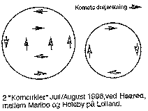 data from Lillian and Reinold Hansen
Description: Two circles near each other.
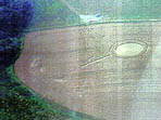
2. Date created: ?
Date measured: August 9, 1996
County: Jylland
Location: Dybbřl, near Sřnderborg
 click here
photo by Kurt Gabs
click here
photo by Kurt Gabs
Description: A ring, 22 by 19.4 meters in diameter. Two paths from it, 16 and 12 meters long, ending in circles, with respective diameters of 6.4 and 4 meters. The ring's and paths' breadth was 1.3 meters.
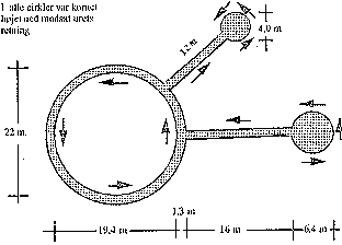 measurements by Poul Erik Folmann
3. Date created: about August 8, 1996
Date found: August 1996
County: Jylland
Location: Sundby Mors
Crop: wheat
Description: Irregular scribble of lines about 200 meters long. The farmer relates that a compass in the middle area vibrated more than at other places in the field. That all the downed straws lay in a westerly direction, despite the lines' twisting curves, and that the straws were pressed so hard down into the earth, that the machine used for lifting them for harvesting couldn't do so.
4. Date created: ?
Date measured: July 25, 1996
County: Lolland
Location: near Holeby
Crop: wheat
Description: In the same field as, and very similar to, the July 16, 1995 formation. Five circles on a cross. The overlapping wheat showed the lay-sequence to be as follows: first the 3 circles at the cross's short ends, then their arms, the central circle, the long arm, and lastly the circle at its end. For the measurements, see the enlarged diagram.
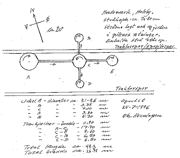 click here
measurements and diagram by Ole Henningsen
click here
measurements and diagram by Ole Henningsen
1995
1. Date created: ?
Date found: Sept. 9, 1995
Date measured: Sept. 17
County: Lolland
Location: near Holeby
Crop: wheat
Description: Two circles of 9 and 9.5 meters, with a connecting path. It's said that the perpendicular path and endways were added later. The circles were irregular, the pathways crooked, and the formation was generally quite messy. For its measurements, see the diagrams.
 idealized drawing by Paul Vigay of the International Crop Circle Database.
For Ole Henningsens diagram,
click here.
For Ove Larsens diagram,
click here.
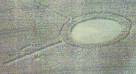
2. Date created: July 16, 1995
Date measured: July 26
County: Jylland
Location: Odsherred, Vejrhřj, near Stupperup
Description: Two broken but concentric circles, each formed by four ca. 3-meter broad arcs. The difference of 1.1 meters between the formation's vertical diameter (40,0 meters) and horizontal diameter (41.1 meters) corresponds to the field's downhill slant at this place. This means that a 40-meter circle projected from the air or from underground would appear as an ellipse with exactly this size, on the field's ground-surface.
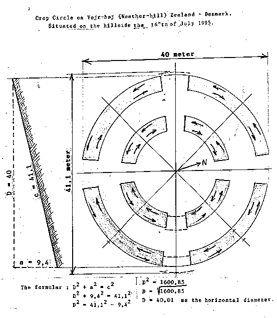 click here
diagram and computation by Karlotto Ernst Lundholm
click here
diagram and computation by Karlotto Ernst Lundholm
The drawn symbol is idealized, whereas the stippled lines between the arcs show it's actual size.
1993-4
Date created: ?
Date found: the next morning
County: Jylland
Location: Sejlflod, north of Aalborg
Crop: Grass
Description: A reversed "N" found within a small, fenced-in, knee-deep field of grass next to a little, homemade 4-sided wooden pyramid. The lines then became broader, and a pattern of flying "stars" was seen over the field. For the farmer's report, click here.
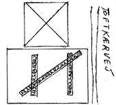 click here
drawing by Borg Jensen
click here
drawing by Borg Jensen
Related subjects at this website:
Feel welcome to write. My e-mail address: jonah102@gmail.com